State

CA electricity consumption by sector

Source: 

http://www.lbl.gov/Science-Articles/Archive/energy-myths2.html

Image: 

All major sectors of California's economy show modest, steady growth over the last decade. Between 1995 and 2000, the state's electricity consumption overall, as well as its residential sector, grew 2.5 percent per year. This growth rate is not unusual for the state when compared to the historic record, and is moderate when viewed in the context of the growing population and economy.

Image Type: 

Category: 

Level: 

Geographic Area: 

Extended nuclear generation outage increases Southern CA's energy prices relative to Northern CA

Source: 

http://www.eia.gov/todayinenergy/detail.cfm?id=10531

Image: 

Historically, wholesale power prices for Northern and Southern California tracked closely with one another, indicating minimal market differences between the two areas. However, after the shutdown of SONGS in early 2012, the relatively inexpensive nuclear generation produced by SONGS had to be replaced with power from more expensive sources. Consequently, since April 2012 Southern California power prices have persistently exceeded Northern California prices, with the spread averaging $4.15/MWh, or 12% of the Northern California price.

Image Type: 

Category: 

Level: 

Geographic Area: 

CA energy demand forecast

Source: 

http://www.energy.ca.gov/2012publications/CEC-200-2012-001/CEC-200-2012-001-SF-V1.pdf

Image: 

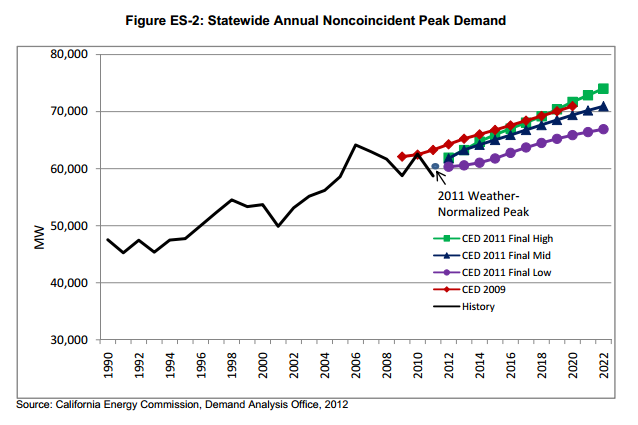
Unlike consumption, peak over all sectors in 2010 was very close to the CED 2009 statewide projection; although 2010 was a mild weather year overall, a heat storm event(extended heat wave) in September 2010 yielded a relatively high peak. The figure also indicates noncoincident weather‐normalized peak demand in 2011, higherthan the actualtotal since this was a relatively cool year. Growth rates in the forecast period are calculated relative to this weather‐normalized total, which is significantly lowerthan the peakpredicted in CED 2009.

Image Type: 

Category: 

Level: 

Geographic Area: 

VMT in CA

Source: 

http://next10.org/sites/next10.huang.radicaldesigns.org/files/2013%20California%20Green%20Innovation%20Index%20031913.pdf

Image: 

Total vehicle miles traveled (VMt) and VMt per capita declined slightly from 2007 to 2010 (-1% and -3.2%, respectively), though both increased compared to 2009 (Figure 34). Greenhouse gas emissions from transportation dropped by a much wider margin, with a ten percent drop in per capita emissions between 2007 and 2010, and a continued improvement since 2009 in both overall transportation emissions (-0.3%) and per capita transportation emissions (-1.1%).

Image Type: 

Category: 

Level: 

Geographic Area: 

Storm risk in India

Source: 

http://proceedings.esri.com/library/userconf/proc02/pap0701/p0701.htm

Image: 

Storm risk in India

The image shows a risk map of India, which was developed using a geoinformation software. The map uses historical data to visualize the past storm areas.

Image Type: 

Category: 

Level: 

Geographic Area: 

Federal Emergency Management Agency

Source: 

http://www.fema.gov/

Image: 

Federal Emergency Management Agency

FEMA is an organisation located in the United States. Its mission is to support citizens and first responders to ensure that a nation works together to build, sustain, and improve its capability to prepare for, protect against, respond to, recover from, and mitigate all hazards.

Image Type: 

Category: 

Level: 

Geographic Area: 

Flood mitigation measurements in the Netherlands

Source: 

http://blog.fabric.ch/index.php?/archives/2009/01/27.html

Image: 

Flood mitigation measurements in the Netherlands

The image shows how the Netherlands is trying to prevent flooding due to the rise in sea level. There are several projects going on, which try to prevent flooding, especially in areas with a high population density.

Image Type: 

Category: 

Level: 

Geographic Area: 

New Mexico Maps

New Mexico Maps
Show

 This map is a work in progress. The uses of water, air and land are diverse in New Mexico and will change dramatically with climate change. For caretakers of this sacred trust, the map offers a bird’s eye view of the health of our environment. It documents primarily the energy-related sources of pollution, though in New Mexico other polluting factors are also at work.

Year: 

Category: 

Story category: 

Level: 

Geographic Area: 

Pages